
Regency Road to Pym Street
Regency Road to Pym Street upgrade
The Australian and South Australian Governments have jointly committed $354.3 million to construct the project as part of their overall commitment to build a non-stop North-South Corridor.
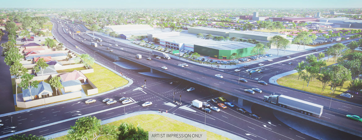
The project includes the design and construction of a new 1.8 kilometre section of non-stop motorway along South Road, as part of Adelaide’s North-South Corridor initiative.
The new Regency Road to Pym Street motorway will connect the completed motorway sections to the north of Regency Road (South Road Superway) to the completed motorways section (Torrens Road to River Torrens Project) terminating north of Torrens Road. This will result in a 47 kilometre non-stop motorway between Gawler and the River Torrens, and continues to deliver on the Australian and South Australian Governments’ commitment to complete the North-South Corridor.
The Regency Road overpass opened to traffic in late March 2021. Full project completion which includes landscaping, ITS commissioning and final asphalting is scheduled to be complete by the end of 2021.
The project comprises an at-grade motorway from the existing motorway infrastructure to the north (South Road Superway); an overpass of the motorway over Regency Road; and an at-grade motorway from Regency Road to Pym Street, transitioning to the lowered motorway infrastructure (Torrens Road to River Torrens Project). The concept design includes:
- A 1.8 kilometre section of non-stop roadway, providing three lanes in each direction (at-grade).
- Two lanes in each direction on the South Road surface road, providing access to the surrounding community and local businesses.
- An overpass over Regency Road (three lanes in each direction). Two lanes in each direction (at-grade) on the surface roads underneath.
- Left in and left out only access at Pym Street.
- Full access to and from the non-stop motorway at Regency Road.
- Intersection upgrade at Regency Road.
- Improved cycling and pedestrian facilities.
- A grade separated pedestrian and cycle overpass over South Road in the vicinity of Pym Street.
- Landscaping and noise barriers.
Please click here to view the final design
The project once complete will deliver travel time savings of up to 8 minutes during peak periods (or 4.5 minutes on average) on South Road between Regency Road and Pym Street.
The Department COVID-19 Response
The Department will continue to tailor community engagement opportunities in line with the latest COVID-19 advice from health authorities.
Face-to-face engagement opportunities may be restricted and we will continue to be guided by the advice of health authorities, with the health and safety of our stakeholders always our highest priority.
Engagement with community and industry is crucial and we will facilitate information sessions as much as possible to enable face to face engagement. It is important to assist in managing these events that you register as requested to enable physical distancing as much as possible.
Successful tenderer announced for the North-South Corridor, Regency Road to Pym Street Project
The Australian and South Australian Governments have announced the successful tenderer for the major works contract on the $354.3 million Regency Road to Pym Street Project.
A consortium of McConnell Dowell Constructors (Aust) Pty Ltd, Mott MacDonald Australia Pty Ltd and Arup Group Pty Ltd, will design and construct a new 1.8-kilometre motorway along South Road, connecting the South Road Superway to the Torrens to Torrens Project.
To view the full media release please click here.
For more information on the project construction phase please:
- email dit.communityrelations@sa.gov.au
- telephone 1300 794 880